


The Tibet Aerial Survey project posed a challenge our field survey, as we had to operate at an altitude of 4500 meters with a vertical drop of 1400 meters. The biggest was the lack of roads into the survey area We had to search for a suitable takeoff and point approximately 15 kilometers outside the designated area. The aircraft had to climb 500 meters before flying over the for 15 kilometers and then descend 700 meters to follow the survey Thanks to the Feima V10’s exceptional vertical takeoff and landing capabilities, extended endurance, and ability to fly at high altitudes, we were able to overcome various extreme air currents and successfully complete the mission.

High-precision, long-range handheld LiDAR scanner developed by Feima Robotics
Learn more
Slam200
handheld
lidar scanner


SLAM2000 is another innovative industry-level handheld laser scanner developed by Feima Robotics.
Learn more
Slam2000
handheld
lidar scanner

Feima X-1
Feima Intelligent Aerial Photogrammetry,Remote Sensing,
Inspection,Emergency Command and Logistics Transportation System

Learn more

designed for use in various hazardous working environments, including underground and gas mines
Learn more
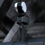
Slam100
intrinsically safe
handheld
lidar scanner


Slam100
handheld
lidar scanner
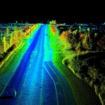
SLAM100 is the first handheld mobile LiDAR scanner launched by China feima-Robotics Co., Ltd.
Learn more


oblique payload
for dJI uAV platform
DP500 is a tilt photography module developed by Feima Robotics based on market demand, designed to adapt to the DJI UAV platform
Learn more


Feima D2000S
One-stop high-precision operation platform based on high-performance rotor platform
Learn more